What Fun!

#1
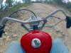
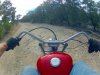
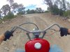
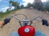
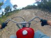
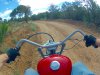
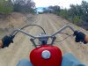
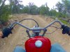
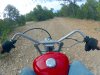
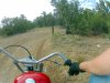
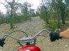
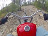
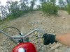
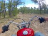
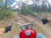
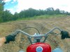
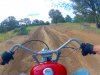
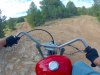
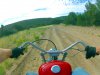
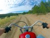
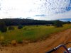
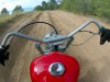
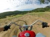
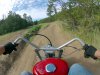
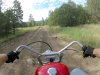
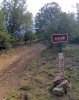
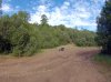
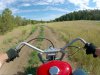
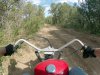
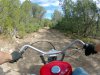
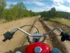
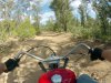
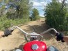
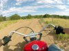
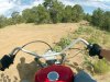
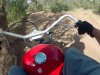
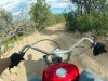
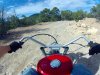
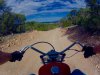
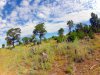
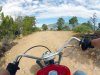
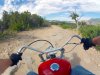
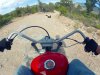
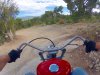
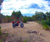
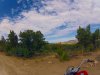
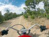
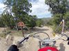
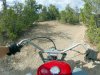
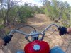
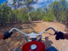
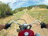
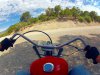
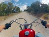
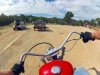
I took the bike on a 25 mile ride today in the mountain. I stayed on Forrest Roads this time just for something different. What fun! There were rocks ,tree roots and three foot deep ruts and powdered soil to test one's skills.
The weather was nice and then clouded up and started to rain just as I was on the last leg back to the car.
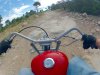
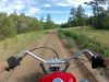
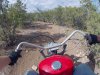
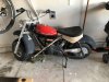
The new carburetor had no problem running at 10,000 feet,with most of the ride at 8,500 feet ASL.
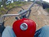
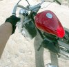
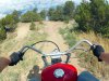
Every thing worked as it should. I did loose 1/2 gallon of water after driving over some boulder fields. Like Hansel and Gretel, I left a tail and found the two water bottles a mile apart in the middle of the dirt road about 1/2 way through the climb on the way back.
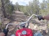
I just ordered a front fender rack for a Harley MC to carry the water up front where I can see it. The dimensions of the rack show it will fit like a glove on the Baja Mini front fender.
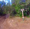
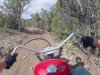
There was not another soul to be seen on the three hour ride. Lots of critters. The weather here has been wet for us. This has produced a nice crop of black flies. I'm always amazed that they can keep up with me as I gun the bike to get away from them on the flats.
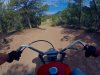
The nice thing about riding in the mountains is half of the ride is down hill. This really helps the gas mileage and allows things to cool down a little.
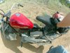
Now it's time to clean the bike and lube the clutch and chains. So far so good.
 
#5
To get to the Forest Roads one must climb the mountains to get to them. Many Forest Roads are the result of Forest Fires ( Smokey Bear is a New Mexican ) or for maintaining Cell towers on mountain peaks.
I needed to climb from 7,800 feet ASL up to 10,000 feet ASL to reach many of the roads. Depending on the prevailing winds these mountain tops can be lush green or just scrub pines from lack of water or older burn scar growth.
Since these are the "Rocky Mountains",there are a lot of them.
I found this area talking to one of the Forest Rangers who told me it would be a nice ride,just don't rut the road if it rains...? OK. He also said that FR13 is a difficult road in several places and I may have trouble not being a UTV.
So far I have yet to find a road/trail I could not climb as long as it could be climbed safely.
There is little to no cell phone service. Garmin GPS works most of the time. I will be 60 miles from any medical services,so common sense is needed at all times.
The 2D camera really does not show how steep many off the trails and roads are. I try to get some perspective shots to shown in many places it would be hard to stand upright let alone walk up the slopes.
I'm always finding bike and vehicle parts that have been torn off by drivers hitting boulders and ruts. Many of the monster boulders are so smooth crossing them is like driving on ice. You'll see a lot of carbon on these boulders from slipping tires.
Tree roots are killers as well. Not only are they slippery if you hit them at an oblique angle they are right at foot peg height just waiting to stop the bike and throw you over the handle bars. I'm glad I kept the phony gas tank on the bike. It has stopped my balls from being blasted out of my ears on several abrupt stops had I hit the bikes frame rather than the tank shroud.
Here is thee start of the climb. rocks of course.
FRA.JPG

FR1.JPG FR2.JPG

FR3.JPG

I'm climbing and have gone about 1/2 mile by now,up around 9,000 ASL and still climbing

FR4.JPG
Traction is the key here. You want to keep a constant speed if you can, gunning the throttle is asking for trouble, I try to keep it at 15-20 MPH.
FR5.JPG
This is one of the slippery boulders. It is about 10" higher than the road and as you bounce over the leading edge, you want to goose the throttle which is the worst thing you could do. The rear tire will slip off to the left ( in this case) and dump the bike onto the boulders face. A go way to destroy you knee. Going left/right puts you in loose gravel which is just as bad as it is very steep here. I lost one off the water bottles not too far from this boulder.
FR6.JPG
Here is a good reason to hit boulders dead on. I hit one with the balloon tire at a slight angle to the left, it threw the front end to the left instantly.
I regained balance just before the next section of boulders.
The photo's may look like I'm sailing right along in a straight line. No so. You are constantly fighting to keep the bike on a safe path through the rocks a loose gravel.
FR7.JPG

The camera caught almost how steep it really is. There is a lot of rear tire spin as the soil is very loose. The gravel being picked up and bouncing around in the rear fender sounds like a Chinese Heavy Metal Band.

FR8.JPG
Still climbing and out of most of the boulder fields. I can move out for a short ways.
FR9.JPG
This is a nice 30 degree climb. The bike really digs in and moves out well with these balloon tires at 4 PSI. The ride is fairly smooth as well.
FR10.JPG
To good to be true I hit the 2ND long boulder field. It got worse real quick.
FR11.JPG
The forest road slit from 12 and joined 13, the road I was warned about.

FR12.JPG
I decided to at least check it out. After all, how bad could it get?
FR13.JPG
Ah, OK this is a challenge. large loose rocks and a steep incline.
FR14.JPG
Man it is getting worse and steeper. Those "small"rocks are thee size of bricks. The soil underneath is powder. Almost no traction at all.
Shirley it must end soon?
 
#6
I missed the 5 minute rule to edit thee spelling mistakes,sorry.
Here are a few more,with plenty left to post.
*****************
How bad could it get?
FR15.JPG

It got so steep,...how steep?.... as in no more traction what so ever. The clutch was red hot and smoking. not the place to destroy any bike parts.
FR16.JPG
Back down the road for 1/2 mile. Next time I'll listen to the Ranger.

FR17.JPG
Back on FR12 again. Ruts are starting to show up and are much deeper.

FR18.JPG
Another cross road. All the signs are gone. Go right young man.....

FR18.JPG
 
#7
The site had a problem and locked up for a minute. duel post for the last photo.
FR19.JPG
The ruts are getting worse. These are at least two feet deep. I'm riding where the UTV's and trucks have bottomed out.
I learned the bike has "Torque Steer" even though the two tires are aligned. I had to open thee throttle with ease or chance being driven into the ruts. Instant foot peg grab and a wreck. The ruts went on for about 500 yards.
FR20.JPG
The roads split again. and again no signs,no cell service and the map did not show this. I went left.
FR21.JPG
Boy what a ride here! It was pretty smooth for several miles. We are going down hill from 10,000 feet.

FR22.JPG
This was so nice. There is a huge meadow on the left. very green.Road stayed relatively smooth for another mile.

FR23.JPG
Not knowing just how far I had gone and where the road goes,I stopped by the meadow to consult the map and "guess" where I was.
There are no road signs,and no one else around. I'm on the top of a mesa at 9,500 feet ASL.

FR24.JPG FR24.JPG
Back to ruts again. Still on FR12 and depending. Weather looks a little threatening. Still pushing on.

FR25.JPG
The road narrowed and went up and over a good rise. now down again. Still no signs to be seen.

FR26.JPG

Back into the open again. A ridge is intersecting up ahead. hopefully there are sign post.

FR27.JPG
Descending on the East slope of the mountain. That is an arroyo on my left,deep and has been hit by others.

FR28.JPG
It's a whole different world here, lots of real trees and grasses.

FR29.JPG

wow, end of the FR12 main road and two branches. Lone pine is a very long way from where I though I may be.

FR30.JPG
You can tell many others have stopped here to get their bearings. The trees are so nice here. I stopped to stretch my legs and drink some water.
I lost 1/2 gallon of water on the trail! Good thing I always carry a spare quart.
FR31.JPG
The other trail was open to anyone and anything to try. There was no signs of any truck or Jeep had even tried it. The trail was very steep.
At this point I checked the gas level and decided to turn around and head back.The weather was changing ( it does every 20 minutes) and I had driven 14 miles. I had extra fuel but knew the trip back was going to be at least another 12 miles if I took a short cut.
I will continue with the return trip later on.
 

Attachments

#8
Ok, now its time to ride back to the car.
FR32.JPG
I really like how green it is here, not normal for us.
FR33.JPG
This grass meadow went for a few miles.

FR34.JPG
As I climb back up just a hundred feet or so,the plants and trees change their types and sizes. This is New Mexico.

FR35.JPG
The higher you go,the more sparse the plant life is. It gets very cold here. 25 below zero is not uncommon in the mountains.
It get 16 below at my house some winters.
FR36.JPG
Back by the ruts. They stretch out of sight. They do keep you on your toes though.

FR37.JPG
Back into the scrub pine trees.
Millions of trees have been killed off due to the Bark Beetle. I've lost hundreds at my home.

FR38.JPG
Beginning my last turn to the cross roads to go up and over the peak to the road back to the car.
FR39.JPG
A nice reminder I'm still on FR12 and going the right direction.
FR40.JPG
At the cross roads once again. The Sun Flowers are just starting to come up.
Since many of the "road" signs are missing,or ever put up many folks will pile rocks as a marker. Some use a tape streamer.
I have used the tape method in the past.
Yes,I can see my tire tracks on most of the trails/roads,but on rocks you may not. With no cell service or sometimes a clear sky for the GPS it is easy to get lost for a novice. So far I have never gotten lost. Many do.
 
#9
The run back down the mountain to my car starts
FR41.JPG
Ruts and tree roots, nothing like the "Double-Whammy" to catch the tired rider. The ruts are filled with dust several inches thick,it's like riding on pancake mix. Keeping the bike upright and in balance is fun to be sure. FR42.JPG
Up and over the crest to start the long down hill ride. You may be able to coast for several hundred yards at a time. The rear brake was really hot.

FR43.JPG
Here come the rocks. There will be miles of them.

FR44.JPG
I just let the bike use gravity to pull it to the car, you could hear the engine ticking as the head cooled. The idle was so quite the chains made most of the noise you heard.

FR45.JPG
I stopped 1/2 way down and was about to put the new kick stand down for a drink of water and a "look-see" over the edge of the mountain.
It was then that I thought I might look for the two missing water bottles,thay may still be in the road somewhere.

FR46.JPG
Just to give you an idea of how steep some of the roads are, I'm standing upright, the trees had to grow at an angle to stay level.

FR47.JPG
Rocks a loose dirt, take this corner too fast and you go over the side of the mountain just ahead.
You'd be out of sight and not found for a very long time. The Coyotes would love you. FR48.JPG
Yep, more rocks. There are many rock outcroppings like this on the road.

FR49.JPG
At my feet is one of the missing water bottles. You get it,thrown out by rocks ( these were tired down with three bungees) FR50.JPG
And a mile down the road was the 2ND water bottle,no worse for wear.( Black Arrow)
A good reason to get that front fender rack. At least I would see them fall off the bike.

FR51.JPG
I'm about three miles from the "Short Cut" ..more of those really slippery baby-butt smooth boulders. Tire skid marks all over the place.
And yes, it is a very steep turn to thee left.

FR52.JPG
I stopped again to check the bike and a drink of water. The rocks and boulders are really bone jarring after 5 miles.
It's prob 85 degrees F now.

FR53.JPG
The white rocks under thee clouds are where the Cement Plat lies. I-40 is just to their right. that's 15 miles away as the crow flies.

FR54.JPG
Good 'old 462 tells me I'm close to the "short cut" to get to my car. The cut will save me two mile of what? rocks of course.

FR55.JPG
I found the short-cut. No trucks or the like. Just over that pipe in front of me was a two foot straight down drop. Some kind person placed a ramp made out of pavers to ease the transition to the trail. Thank you unknown person. This short cut goes for five miles. I only need to go two.
 
#10
So I start the final leg to my car. I have not ridden this trail before. I'm told it is "interesting" to ride.

FR56.JPG
Hey this is nice....

FR57.JPG
up ahead is an arroyo that had been washed out last week. It was a deep "V" Chanel cut into the soil. Both front and rear fenders almost touched at the same time. Thats someones ATV exhaust on the left. I bet many a rider this week went over the handle bars. you can bet I checked the water bottles again after that "ditch". FR58.JPG
Slip slide'in Away. loose powder and rocks right at a steep drop off.

FR59.JPG
Steep downward and to the left, still in loose dust.

FR60.JPG
That stuff was at least a foot deep. There were rocks and stones being flung left and right as I passed through the mounds.

FR61.JPG
Oh Boy back to normal riding. downhill.

FR62.JPG
A long steep decline to be foll wed by a very steep rise to the road going to the parking lot.

FR63.JPG
In the 'Home Stretch". I'm gathering up as much speed as I can,the rise is very steep and is gravel.

FR64.JPG
Up,Up climbing as fast as I can. you can just see a pole that marks the end of the trail ( for this leg)

FR65.JPG
Just cleared the top of the rise to he parking lot road.

FR66.JPG
A high speed run the last mile to the parking lot to blast out any carbon and shake loose any hitch-hiking rocks.

FR68.JPG
Back at the car again after three and 1/2 hour ride. Garmin shows just under 25 miles round trip. I had little gas left in the tank,The engine would have died if I went up hill again.
The bike came through again and I swear it was glad to be put into its rack in the trailer to go home....
Hope you enjoyed the photo's and the Sea Stories. I know there is no mindless music and cussing, Just the bike and the great outdoors.
Rapidrob.
 

CDog

New Member
#11
Awesome post. This is the sort of stuff I want to do with my minibike. Do you have a link to details about your bike? Specifically, the gearing that lets you do climbs on dirt trails?
 
#13
wow!! what an adventure!! what kind of bike did you start off with? i've got a baja warrior that is finally running strong and consistent. now it's time to find some old fire roads and go for a rip. i also got bluetooth installed on my helmet. that is a big deal! IMG_6664.JPG IMG_6618.JPG

thanks,

jason
 
#15
It was just a plain Jane Hawg Ty. I have not modified the engine other than adding an alternator to it to power lights and a cell phone/GPS.
I also added a Torque Converter drive system, a real LED head light, and a battery pack with electronics to control AC to DC power and charge each battery cell one at a time wit ha now phony gas tank mounted monitor.
( See my post and the videos )
 
Top